The recent collision between the US warship and Liberian tanker in the Singapore Strait has raised concerns for safety of navigation in swarming anchorages, especially the Singapore Port. With myriad of ships travelling in and out of Singapore offshore on a daily basis – sea safety becomes a top priority. While China blames the US Navy (for the mishap) for endangering maritime navigation in the region in its efforts to safeguard the freedom of navigation in the South China Sea dispute, are we taking for granted the underlying risks that pose threat to the safety of ships sailing in the Singapore Strait?
The Singapore Strait is one of the world’s busiest shipping sea lanes that host various navigational challenges – namely geographical, weather and traffic constraints. Located between the Malacca Strait (on the west) and Karimata Strait (on the east), the strait is 56 nautical miles long and eight nautical miles wide. The strait is also covered by Singapore on the north and the Riau Islands, Indonesia on the south. As the strait is the primary deep-water passage for ships to reach the Singapore Port, it has become one of the demanding sea route – with an average of 100,000 ships passing through it every year.
Geographical challenges
As the Singapore Strait is only 8 nautical miles wide, it creates one of the most congested traffic points in all of world’s sea routes. Being one of world’s busiest shipping lane, the congested traffic makes the narrow passage difficult for vessels to navigate and safety can become a primary concern.
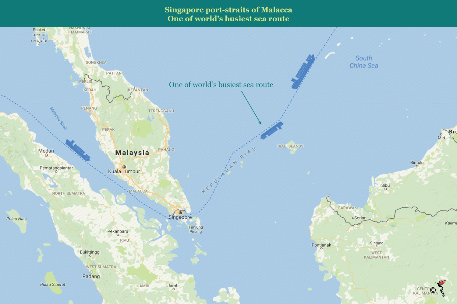
The sea route used by ships that navigate through the Singapore Strait.
The most difficult stretch for navigation is the strait is in areas spanned by the Traffic Separation Scheme (TSS). The TSS spreads for 250 nautical miles and has six traffic points where the average depth may be as shallow as 25 metres (or 82 feet in some). Under the TSS, ships that travel in and out of the straits travel in two separate lanes respectively to ensure the traffic is properly dispersed – in efforts to reduce or avoid accidents at sea. The depth of the strait also limits the maximum number of vessels going through the Singapore Strait – especially for larger oil tankers.
Weather challenges
According to a research done by National University Singapore’s Centre for Maritime Studies on ship traffic in the Singapore Strait, the visibility of the strait is influenced by haze from Indonesia and heavy rains in Singapore. Considering these weather challenges, the visibility in the strait falls under two levels, namely low visibility (2-5 nautical miles) or good visibility (greater than 5 nautical miles).
The occasional presence of haze in Singapore is primarily caused by the forest fires in Sumatra, Indonesia and the strong winds blow them across the sea towards the strait. With the haze, the visibility in the strait would be significantly reduced. The region is also subjected to frequent rain and storms, and strong currents can be experienced during the transit through the strait.
Restricted visibility and challenging weather conditions make it difficult for seafarers to navigate their vessels. During periods of restricted visibility and challenged weather conditions, shipmasters are advised to keep a proper lookout and navigate with caution. The shipmasters are to comply with international regulations pertaining to preventing collisions at sea and rules concerning conduct of vessels in low visibility with display of navigation lights and sound signals, as well as proceeding at a safe speed – which is called Convention on the International Regulations for Preventing Collisions at Sea, 1972 (COLREGs).
Traffic challenges
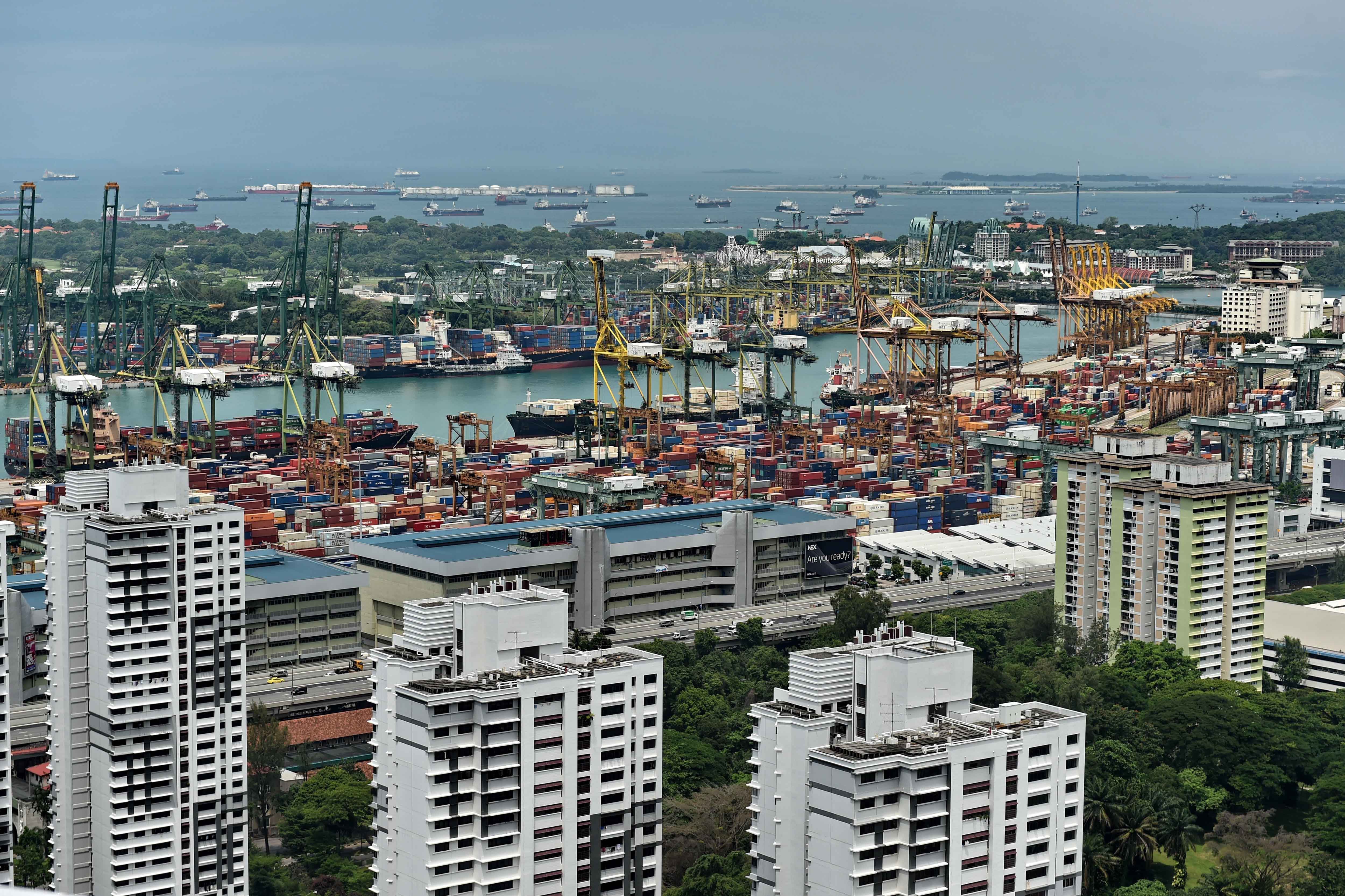
The Singapore Port is the world's second-busiest container port in terms of total shipping tonnage. This is mainly driven by the fact that the Singapore Port serves as an economic advantage for Singapore as the country lacks land and natural resources. The port is crucial for importing natural resources, exporting refined products and in creating opportunity for ship-related food and beverages services. Thousands of ships drop anchor in the Singapore harbour, connecting the port to over 600 other ports in 123 countries and spread over six continents.
The Singapore Strait becomes equally demanding in ship traffic because ships that travel from the Pacific Ocean to the Indian Ocean, and vice-versa, can use only this shipping route. The Johor Strait (located at the north of Singapore) is not made accessible to ships due to the Malaysia-Singapore causeway.
The shipping industry has gain traction in the recent times, where shipping traffic is becoming more congested – as the sizes of ships grow larger and the frequency of ships navigating to and fro increases. Under such circumstances, the challenge for shipping safety at the straits becomes important. Shipping hazards such as grounding, collision or contacting becomes a serious problem in prominent sea hubs such as the Singapore Port and Singapore Strait – where we have prevalent high shipping traffic, narrow routes and challenging weather conditions.