When the progress towards achieving the goals of the 2030 Agenda for Sustainable Development as of 2017 was assessed earlier this year, the situation had worsened most significantly for the Southeast Asia sub-region when it came to containing the loss of land area covered by natural forest. The indicators measuring action to protect, restore and sustainable use of forests and forested land is covered under Sustainable Development Goal (SDG) 15.
While deforestation and degradation of forested land are major issues for the region, the condition in one country in particular, Indonesia, is alarming. A joint study carried out by the University of Maryland (UM), Google, The United States Geological Survey (USGS) and the National Aeronautics and Space Administration (NASA) under the Global Forest Watch (GFW) found that more than 227,000 square kilometres of forest cover was lost between 2001 and 2016. The area is more than twice the size of South Korea.
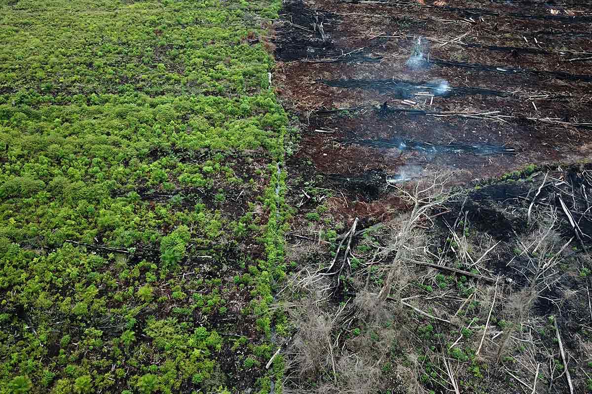
The forest cover lost in the region was largely driven by demand for natural resources and land clearing for producing food and other commodities. In Indonesia, specifically, the main driver for deforestation is the practice of slash-and-burn to establish palm oil plantations. The practice is a major contributor to the transboundary haze issue that is impacting millions of people in the region, mostly in Indonesia, Malaysia and Singapore. This is further enabled by poor enforcement and weak governance.
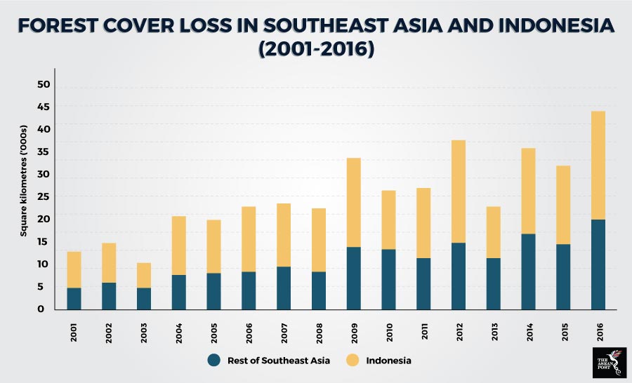
Sources: Google, University of Maryland, USGS and NASA.
Real-time forest management and deforestation monitoring are generally challenged by inaccurate, incomplete and outdated information. When data is available, such as in the case of NASA satellite imagery, it is not at a resolution or consistency that is sufficient for enforcement. Hardware that is crucial to processing and viewing the data is also beyond the reach of developing nations, advocacy organisations and other groups that need it the most.
Through the collaboration of Google, UM, USGS and NASA, the online platform GFW has released a global forest map, the largest catalogue for earth observation data, updated at near-real time. Akin to the human genome project but based on earths’ ecosystems, the GFW’s map boasts fine enough resolution to detect even small-holder agricultural activities. It provides data and tools for monitoring forests for free to non-profit organisations, as well as forest management and law enforcement agencies in tropical countries.
Deforestation-free palm oil in your products
Despite commitment in sourcing only sustainable palm oil, an average business may not have the capability to do so as the verification of the whole supply chain involves hundreds of processing mills and is too complex. To ensure that palm oil sourced for products does not come at the cost of widespread deforestation, especially in Indonesia and Malaysia, companies may use the GFW’s Prioritizing Areas, Landscapes and Mills (PALM) Risk Tool.
According to an article by Sarah Lake and Octavia Payne on the GFW blog, the PALM Risk Tool illuminates points in companies’ palm oil supply chains that are most likely to be associated with past and potential future deforestation. The information provided by the PALM Risk Tool, developed in collaboration with Proforest and Daemeter, enables companies to make informed decisions on how to reduce and eliminate the use of palm oil sourced from areas prone to deforestation.
The PALM Risk Tool uses satellite-based data to measure deforestation risk for nearly 800 palm oil mills, with new mills being added all the time. The tool analyses fire activity and tree cover loss occurring over time and in environmentally important landscapes such as primary forests and carbon-rich peatlands within a 50-kilometre radius of each mill, which is the distance fresh palm fruit can travel without spoiling. The risk ranking of each mill is based on these criteria.
“Palm-oil driven deforestation typically occurs when land is cleared for plantations. Companies that identify a “high-risk” mill in their supply chains can then do additional research, conduct field audits and engage directly with plantations supplying that mill to ask them to change their practices,” explained Lake and Payne.
When the European Parliament voted to ban the use of palm oil for the production of biofuels in the European Union (EU) by 2020 in an attempt to stop deforestation of rainforests, mainly in Indonesia and Malaysia, the relevant governments opposed the claim. Innovation such as the global forest map allows all parties not only to substantiate their claims, but also work towards reducing the impact of palm oil on ecosystems. It is one opportunity that should be seized upon.
Related articles:
EU palm oil ban sows bitter seeds